Lake Eyre Australia Facts: Everything About Kati Thanda–Lake Eyre
Lake Eyre, officially known as Kati Thanda–Lake Eyre, is one of Australia’s most extraordinary natural features. It holds two remarkable records at once: it is Australia’s largest lake and also the lowest point on the continent, sitting around 15 metres below sea level. Yet most of the time, visitors won’t see water at all. Instead, Lake Eyre appears as a vast, blinding white salt pan stretching to the horizon, dry, cracked, and seemingly lifeless.
For tens of thousands of years, this place has held deep cultural meaning for the Arabana people, who know it as Kati Thanda. European explorers later named it Lake Eyre after Edward John Eyre, who reached the area in 1840. Beneath its quiet surface lies the heart of the Lake Eyre Basin, a massive inland drainage system covering almost 15 per cent of Australia.
What makes Lake Eyre truly fascinating is its unpredictability. In rare years, floodwaters surge into the basin, transforming the desert into a shimmering inland sea alive with birds, fish, and colour — a phenomenon few landscapes on Earth can match.
Geography and Physical Facts
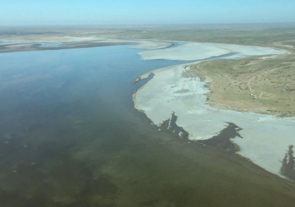
Lake Eyre is located in northern South Australia, approximately 700 kilometres north of Adelaide, within an arid and remote landscape. The lake is made up of two main sections: Lake Eyre North, the larger and deeper basin measuring roughly 144 kilometres long and 65 kilometres wide, and Lake Eyre South, which is smaller at around 65 by 24 kilometres. These two basins are connected by the narrow Goyder Channel, which only carries water during significant flood events.
When completely full — a rare occurrence — Lake Eyre can cover up to 9,500 square kilometres, making it larger than some European countries. Despite its size, it is surprisingly shallow, with a maximum depth of about six metres. The lake floor lies around 15 metres below sea level, the lowest natural point in Australia.
The surface is coated with thick layers of salt, in places reaching 50 centimetres deep. These salt crusts formed over thousands of years as repeated cycles of flooding and evaporation left minerals behind. Geologically, the lake evolved through a mix of tectonic movement, wind erosion, and ancient inland seas dating back to the post-Pleistocene period. Its catchment stretches across Queensland, the Northern Territory, South Australia, and parts of New South Wales, making it one of the most expensive drainage basins on the continent.
Hydrology and Climate
Lake Eyre is part of an endorheic system, meaning water flows into it but never reaches the ocean. Instead, all incoming water eventually evaporates. The lake is primarily fed by long-distance river systems such as the Warburton River, Cooper Creek, and the Georgina–Diamantina system, which carry monsoonal rains from northern Australia and western Queensland.
The climate around Lake Eyre is extremely dry. Average annual rainfall ranges between 100 and 150 millimetres, while evaporation rates are among the highest in the world, estimated at 2,500 to 3,500 millimetres per year. This imbalance explains why even large inflows often disappear before the lake fills.
Since European records began in the 1860s, Lake Eyre has filled completely only three times, most notably in 1974, when water depths reached around six metres. Partial flooding occurs more often, roughly every three to ten years. As floodwaters evaporate, salinity rises rapidly, sometimes becoming hypersaline. During these stages, the lake often turns shades of pink due to blooms of Dunaliella salina, a salt-loving algae.
Over the past century, several proposals suggested piping seawater into Lake Eyre to create a permanent inland sea. All were abandoned due to environmental risks, extreme salt accumulation, and unmanageable evaporation rates.
Ecology and Wildlife
Despite appearing lifeless for long periods, Lake Eyre supports one of Australia’s most dramatic boom-and-bust ecosystems. When floodwaters arrive, microscopic phytoplankton such as Nodularia flourish, forming the base of a short-lived but intense food web. Fish species including bony bream and golden perch are carried downstream from northern river systems, spawning rapidly in the fresh conditions.
As the lake dries and salinity increases, these fish often perish in large numbers, providing an essential food source for birds. Lake Eyre is internationally recognised for its birdlife and is listed as an Important Bird Area. During major floods, the lake has supported extraordinary numbers of waterbirds, including up to 200,000 Australian pelicans during the 1990 event — around 80 per cent of the national population at the time.
Other notable species include banded stilts, red-necked avocets, and silver gulls, many of which travel vast distances to breed here. The lake and its surrounds are protected within Kati Thanda–Lake Eyre National Park and the Elliot Price Conservation Park, and it is also listed on Australia’s Directory of Important Wetlands.
History and Human Significance
For the Arabana and Dieri peoples, Lake Eyre has been central to culture, law, and survival for thousands of years. Dreaming stories describe the lake’s creation and the cycles of water and life that define it. In 2012, native title over much of the area was formally recognised, affirming the enduring connection between Traditional Owners and this landscape.
European awareness of the lake began in 1840, when explorer Edward John Eyre encountered its southern edges. Early settlers were often misled by flood events, believing the region suitable for agriculture. One of the most enduring pastoral ventures was Anna Creek Station, established in the 1880s and now recognised as the largest cattle station in the world.
Lake Eyre has also played a role in modern Australian history. In the 1960s, its flat salt surface attracted land speed record attempts, including Donald Campbell’s famous run, which reached over 400 miles per hour. During wet years, the Lake Eyre Yacht Club famously holds sailing regattas — one of the few places on Earth where yachts race on a temporary desert lake.
Visiting and Tourism Tips
Visiting Lake Eyre requires planning, but the experience is unforgettable. The most common access route is via the Oodnadatta Track, leading to William Creek and viewpoints such as Halligan Bay. Road conditions vary greatly and can become impassable after rain, so checking local updates is essential.
For the best perspective, scenic flights from William Creek, Marree, or Coober Pedy are highly recommended. From the air, the lake’s scale, colour shifts, and salt patterns are truly visible. Flood periods offer exceptional birdwatching and photography, while dry years highlight the lake’s surreal salt formations and mirages.
Camping is permitted in designated areas like Halligan Point, but visitors must be fully self-sufficient. The region remains active for cattle grazing and mining, so respecting signage and access rules is important. Photographers should aim for early morning or late afternoon light, when the salt pan reflects the sky. With increased rainfall patterns predicted in 2025, interest in potential flood events remains high.
Conclusion
Lake Eyre is a place of extremes — dry yet alive, harsh yet beautiful. It shifts between a silent salt desert and one of Australia’s most important inland wetlands, reminding us how finely balanced arid ecosystems can be. Beyond its geography, the lake carries deep cultural meaning and ecological importance that deserves protection. As climate patterns continue to change, understanding and respecting Kati Thanda–Lake Eyre has never been more important.
Frequently Asked Questions
-
Completely filling is extremely rare, occurring only three times since the 1860s. Partial flooding happens every few years.
-
Floods attract fish, frogs, and enormous numbers of waterbirds, including pelicans, stilts, and avocets.
-
Yes, but access depends on weather and road conditions. Scenic flights are the most reliable option at any time.
-
Yes. It is part of Kati Thanda–Lake Eyre National Park and is listed as an important national wetland.