Lake Eyre Basin Rivers and the Drainage System Explained
When most people think of Lake Eyre, they picture a vast, empty salt pan stretching to the horizon, a white desert that seems completely lifeless. But what many don’t realize is that beneath its barren surface lies a story of movement, life, and rare beauty. Lake Eyre, or Kati Thanda as the Arabana people call it, is the centrepiece of one of the largest endorheic basins in the world.
Water doesn’t flow out to the ocean here. Instead, it is collected, channelled, and eventually evaporates, leaving behind the incredible salt flats that have fascinated explorers, scientists, and outback adventurers for centuries.
For Australians and tourists alike, understanding the Lake Eyre Basin and the rivers that feed it is more than just geography. It’s about predicting the lake’s moods, planning a trip, spotting wildlife, and knowing why some floods are life-changing while others barely leave a mark. In this article, we dive deep into the Lake Eyre drainage basin, the rivers that feed the lake, the ecological magic that occurs during floods, and how this impacts anyone planning to explore the outback.
What is the Lake Eyre Drainage Basin?
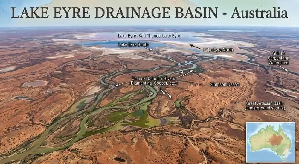
The Lake Eyre Basin is massive, covering roughly 1.2 million square kilometres across South Australia, Queensland, New South Wales, and the Northern Territory. Imagine a region almost half the size of France, where rain is scarce, evaporation is extreme, and rivers sometimes travel hundreds of kilometres without ever reaching the ocean. That’s the Lake Eyre Basin. It’s what hydrologists call an endorheic basin, meaning water collects and stays within the system rather than flowing out to the sea.
The basin is a complex network of rivers, floodplains, claypans, and ephemeral wetlands. When rain falls in the northern catchments, water begins a slow journey through winding rivers and braided channels, often taking months to reach the dry heart of South Australia. Most years, the rivers trickle and evaporate before ever reaching the lake, leaving the basin dry and seemingly lifeless. That unpredictability is what both fascinates and frustrates travellers. People want to visit Lake Eyre when it’s full, yet planning a trip around natural cycles that happen once in decades is a challenge.
For those planning a tour, this is where understanding the basin is crucial. It’s not just about the salt lake itself. It’s about timing, access, and knowing which areas will actually have water and wildlife when you arrive. A glance at a map doesn’t tell the full story; the basin behaves in ways that demand patience, preparation, and respect.
The Major Rivers Feeding Lake Eyre
While the basin itself is vast, a handful of rivers carry most of the life-giving water into Lake Eyre. Each has its own personality, flow pattern, and role in shaping the lake’s rare and fleeting floods.
Cooper Creek
Cooper Creek is often considered the main artery of Lake Eyre. Originating in Queensland, it snakes across the northern plains, forming expansive wetlands during wet years. The water journey is slow. After heavy monsoonal rains, it can take months for water to reach the southern basin. Most years, the creek only fills shallow waterholes along the way.
For travellers, Cooper Creek is both magical and frustrating. When it does reach Lake Eyre, the landscape transforms from a cracked, dusty salt pan into a reflective mirror, attracting tens of thousands of pelicans, banded stilts, and other birds. But because the river only reaches the lake partially every 3–10 years, timing a visit perfectly is almost impossible without real-time flood reports.
Diamantina River
The Diamantina River also begins in Queensland, moving through red sand channels before joining with Cooper Creek in some years. Its flow is highly seasonal and heavily dependent on Queensland rainfall. Unlike Cooper Creek, which has more consistent flow, Diamantina can swell dramatically in a single wet season and then disappear for years.
The river’s unpredictability is part of its appeal. Birdwatchers and photographers who chase the lake during a Diamantina flood often witness a spectacle that is entirely different from Cooper Creek-fed floods. The challenge, however, is knowing when the river will contribute to a full lake. Many would-be visitors miss the prime viewing windows simply because of the delay between rainfall and flood arrival.
Georgina River
Georgina River is the northernmost of the major rivers in the Lake Eyre Basin. It flows across the Channel Country, a labyrinth of ephemeral channels and floodplains that make it one of the most unique rivers in Australia. Most years, it barely reaches Lake Eyre, evaporating in claypans and temporary wetlands along the way. But in very wet years, its contribution is vital, bringing water that sustains fish populations and migratory birds.
Other Minor Rivers
Other smaller rivers, creeks, and tributaries contribute sporadically, including Strzelecki Creek and Warburton Creek. While their flow is less dramatic, they are important for filling wetlands, supporting local wildlife, and creating temporary habitats that attract both native and migratory species.
| River | Source | Approx. Length | Reaches Lake Eyre | Flood Frequency | Key Features |
|---|---|---|---|---|---|
| Cooper Creek | QLD | ~1,300 km | Partial / Full | Every 3–10 yrs | Ephemeral wetlands, pelicans |
| Diamantina River | QLD | ~900 km | Partial | Every 5–15 yrs | Red sand channels, rare floods |
| Georgina River | QLD | ~1,200 km | Rare | Every 10–20 yrs | Channel Country, claypans |
| Strzelecki Creek | QLD / SA | ~250 km | Rare | Sporadic | Short tributary, temporary wetlands |
| Warburton Creek | NT / SA | ~300 km | Partial | Sporadic | Seasonal flow, joins Lake Eyre in northern basin |
How the Lake Eyre Drainage System Works
Understanding the drainage system is crucial for both enthusiasts and tourists. Water doesn’t just flow directly into the lake. The system is a series of interconnected catchments, floodplains, and distributaries.
When monsoon rains fall in the northern catchments, water begins its journey. It first floods the local plains, forming temporary wetlands. Then, depending on the rainfall intensity and landscape permeability, the water moves downstream into the larger rivers. By the time it reaches South Australia, the water may have spread across hundreds of kilometres of ephemeral wetlands, evaporated in shallow claypans, or formed isolated pools.
The process is slow. Some floodwaters take up to six months to reach Lake Eyre, and often only a fraction of the water arrives. For tourists, this means that visiting Lake Eyre to see a fully flooded lake requires patience, timing, and careful monitoring of rainfall reports and river conditions. Real-time information from the Bureau of Meteorology and local stations is vital.
The basin’s extreme evaporation rates, often exceeding 2,500 millimetres per year, mean that even large floods don’t last long. Within weeks, shallow waters retreat, leaving the vast salt crusts visible again. This is part of what makes Lake Eyre so psychologically compelling for Australians: it’s a place of transformation, unpredictability, and awe-inspiring change.
The Ecological Magic of Lake Eyre’s Rivers
When the rivers do reach Lake Eyre, the effect is almost immediate. The otherwise barren lake becomes a bustling ecosystem. Fish like bony bream and golden perch appear, feeding on nutrients washed down from northern catchments. Birds arrive in enormous numbers: in the 1990 flood, over 200,000 pelicans gathered at the lake, alongside banded stilts, black swans, and cormorants.
The floodwaters trigger a boom-bust cycle. Fish spawn and multiply rapidly, only to face high salinity levels as water evaporates. Birds feast on the abundant fish, while ephemeral wetlands become breeding grounds for insects and frogs. For outback travellers, this is both a blessing and a challenge. Wildlife sightings are breathtaking, but they are temporary, fleeting, and dependent on an unpredictable chain of events. Missing the window can mean returning to a dry, empty salt pan.
Protected areas like Kati Thanda-Lake Eyre National Park and Elliot Price Conservation Park help preserve this fragile ecosystem. For those planning 2 day, 3 day, or 5 day tours or camping trips, understanding the river inflows is essential for maximising the wildlife experience and avoiding disappointment.
Implications for Lake Eyre Tours
If you are planning a visit to Lake Eyre, the drainage system and its rivers are more than just geography. They directly affect access, safety, and what you will actually see. Floods can make tracks impassable, requiring careful 4WD planning. Dry years may mean the lake is almost entirely salt crust, with little wildlife and fewer photographic opportunities.
Knowing which rivers are contributing water helps travellers select the best tour times, camping spots, and observation points. Halligan Bay, for example, is ideal during a Cooper Creek flood for birdwatching, while Marree and Muloorina Station offer better access during low or dry years. Seasonal awareness is also critical — the outback is unforgiving, and unprepared travellers risk getting stuck or missing the spectacle entirely.
Maps and Visual Guides
For most visitors, maps are indispensable. An interactive map showing the major rivers, catchments, and floodplains can make the complex drainage system understandable at a glance. Supplement this with satellite images during flood events to illustrate the scale of the river inflows. Visual guides are particularly helpful for first-time visitors trying to conceptualise how water moves hundreds of kilometres to reach the lake.
Conclusion
The Lake Eyre Basin and its rivers are a story of patience, scale, and transformation. From the slow meandering of Cooper Creek to the ephemeral surges of the Diamantina and Georgina Rivers, the basin is a living system that breathes life into one of Australia’s most iconic landscapes. Understanding the drainage system is essential for anyone planning a visit, whether for tours, camping, wildlife observation, or photography. By timing your trip with the natural rhythms of the rivers and floodplains, you can experience Lake Eyre at its most extraordinary — a white salt lake transformed into a reflective, vibrant, and ephemeral wetland that leaves a lasting impression.
Lake Eyre is more than a destination. It’s a lesson in patience, respect for nature, and the beauty of unpredictability. Whether you’re an outback adventurer, a birdwatcher, or simply curious about Australia’s inland rivers, knowing the Lake Eyre Basin and its rivers ensures your experience is unforgettable.
Frequently Asked Questions
-
Cooper Creek is the most consistent contributor, followed by the Diamantina and Georgina Rivers. Minor tributaries contribute sporadically during wet years.
-
It can take anywhere from three to six months, depending on rainfall intensity and evaporation along the way.
-
No. Partial floods occur every 3–10 years. A fully flooded lake has only been recorded about three times since 1860.
-
Yes, but access is limited to 4WD tracks. Always check current road and flood reports before planning a trip.